|
|
Streets of Camden, NJ Raymond Avenue |
|
|
Streets of Camden, NJ Raymond Avenue |
|
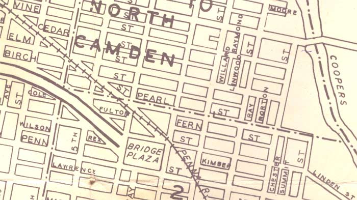
RAYMOND AVENUE runs for one block, north from Vine Street to State Street, between North 7th Street and North 8th Street. Although pair of frame houses and a few other buildings appear on the 1891 Sanborn Map, the avenue itself is not listed, and is not in evidence in the 1906 Sanborn Map either. Raymond Avenue begins appearing in City Directories in 1908. All homes were occupied in 1947. The 1969 New Jersey Bell Telephone Directory show four families living on Raymond Avenue. A reverse directory published in 1980 shows two houses still occupied. By 200 all of the houses were gone. |
|
Do you have a Raymond Avenue memory or picture? Comment at the bottom of the page! Phil Cohen |
| 1946
Map of Camden Raymond Avenue runs north from Vine Street, east of North 7th Street |
|
| Intersection of Vine Street and Raymond Avenue | |
| 700 block of Raymond Avenue | |
| 714
Raymond Avenue
1909 1947 |
|
| 715
Raymond Avenue
1909 |
|
| 716
Raymond Avenue
1909 |
|
| 717
Raymond Avenue
1909 |
|
| 718
Raymond Avenue
1909 |
|
| 719
Raymond Avenue
1909 1967 H. Cruz
|
|
| 721
Raymond Avenue
1909 |
|
| 721
Raymond Avenue
1909 |
|
| 722
Raymond Avenue
1909 |
|
| 723
Raymond Avenue
1909 |
|
| 724
Raymond Avenue
1909 |
|
| 725
Raymond Avenue
1908
|
|
| Intersection of Raymond Avenue and State Street | |
RETURN TO STREETS OF CAMDEN, NJ